
HAVELOCK – ST ARNAUD
Section Distance = 164.5 km
Total Distance = 882.5 km
The Richmond Ranges are said to be one of the longest and hardest sections on the Te Araroa Trail and that was certainly true for me!
11 days from Havelock to St Arnaud, climbing to elevations of 1500m (usually more) on a daily basis, countless river crossings, paths made of little more than a tangle of tree roots and the ever hidden views shrouded in cloud…
“If it doesn’t challenge you, it doesn’t change you!”
HAVELOCK – PELORUS BRIDGE CAMPSITE
The connecting road between Havelock and Pelorus were mostly flat and the gravel was surprisingly ok for the feet but the most challenging part of this day was the pack weight. 10 days worth of food adds a few kg’s.
The campground by the Pelorus River is lovely and I saw hundreds of gloworms in the forest on a little night walk near the camp. I was hoping to spot one of NZ’s native bat species but the rain arrived and I retreated to my tent to listen to the moreporks instead.
PELORUS BRIDGE CAMPSITE – CAPTAIN’S CREEK HUT
This was both a physically and mentally challenging section especially for me carrying so many days worth of food and fighting gravity up the STEEP slopes (with more giant-sized steps required). There were many rest stops in which I would have to convince myself to pick up the pack again…
CAPTAIN’S CREEK HUT – BROWNING HUT
The first 5km from Captain’s Creek Hut to Middy Hut were along the river and over various wire swing bridges = FUN. The next section to Rock’s Hut was 5km of STEEP uphill on a path constructed of slippery tangled tree roots… definitely type 2 fun. The final 11km to Browning Hut was both steep with a few ridges. I got a little frustrated at my slow pace today (although I might also have been hangry). NOTE TO SELF – eat more snacks!


BROWNING HUT – SLATY HUT
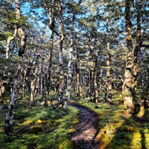
Lovely start to this day, heading down to Hacket Hut (this is where some people choose to pop out and hitch to town for a re-supply so you don’t have to carry as much food as I did for the long section). 8 river crossings and a hard uphill slog to Starvell Hut for lunch and crossed Mt Starvell (1511m). Mossy, misty fairytale forest before the final ascent to Slaty Hut for the night.
SLATY HUT – OLD MAN HUT
The weather is closing in again so a shorter day to reach Old Man Hut before it arrived. Some rock scrambling in places and a narrow ridge with big cliffs either side was a fun traverse. 3 of us in the hut tonight.


OLD MAN HUT – OLD MAN HUT
My first stuck in a hut day! Heavy rain, strong wind and zero visibility meant it was unsafe to cross Mt Rintoul so instead I spent the day in my sleeping bag with the fire on. Very glad I decided to carry in a small book just in case and my biggest decision of the day was, did I need to pee badly enough to put on my full wet weather gear for the 30m run to the loo…
Also managed to restrain myself from eating ALL the snacks as I still had another 5 days before I reach St Arnaud (if the weather improves).
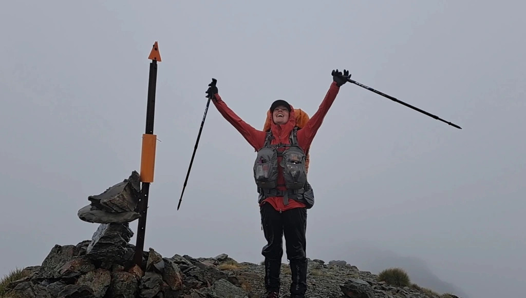
OLD MAN HUT – MT RINTOUL HUT
WHAT A DAY!
The rain had stopped and the clouds lifted so we decided to push on. 200m vertical ascent to regain the ridge from Old Man Hut and headed over the summit of Little Rintoul. A little further on the wind changed and blew the weather system back in. The conditions deteriorated rapidly at this point with heavy rain but thankfully not too much wind.
The narrow trail turned into a waterfall as the water took the easiest route down the mountain. We were about 2/3 of the way to the next hut so decided to push on instead of turning back and the ascent of Mt Rintoul was surprisingly my favourite ascent of the ranges so far (despite the weather). The rocks made for firm footholds which was a change from the mud and slippery tree roots.
No views from the summit but at least the rain stopped at this point. A short walk along the ridge was followed by a steep descent down shale/gravel before hitting the treeline and another 200m vertical descent to Mt Rintoul Hut and it’s warming fire.
Another reminder of how quickly conditions can change in NZ and how being prepared can literally be lifesaving. I had on base layers, fleece layer, rain pants tucked into my gaiters to keep the wind out, and gloves, hat and neck sock under my raincoat.
MT RINTOUL HUT – MID WAIROA HUT
The weather cleared again overnight so onwards to Mid Wairoa Hut. Crossed Purple Top (1532m) and stopped at Tarn Hut for lunch. The track was very slippery after the rain but the hardest part was the 400m vertical descent (oh the knees) which ended with a sing bridge over the river to the hut.
2 more hikers arrived late after a massive day hiking over from Old Man Hut so 5 of us to continue on tomorrow.
MID WAIROA HUT – HUNTERS HUT
Early start for a technically challenging section along narrow ledges, slippery rocks, steep banks and multiple river crossings. I was very glad we could link up for these river crossings as the water was running higher than usual after all the rain and I would not have attempted to cross alone.
Ascending from the river valley over Mt Elis (1615m) before a final steep ascent to Hunters Hut.


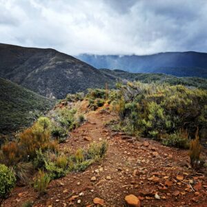
HUNTERS HUT – RED HILLS HUT
Hiking through red hill looks a lot like what I would imagine Mars to look like (but with more gravity). Lots of sidling along the river banks today, several shallow crossings and a boggy marsh on the final stretch to the hut.
We were all very happy to be walking out to St Arnaud tomorrow. Hot shower, washing and eating food I haven’t carried for 10 days were all the top of the list.
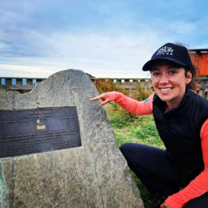
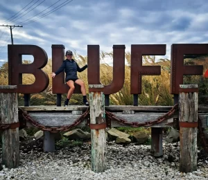
RED HILLS HUT – ST ARNAUD
We left Red Hills Hut bright and early for the walk out to St Arnaud. Left the hut at 5:30am and were eating ice-cream and pies in town by mid-day. Quite a few other TA’s pulled big days to hike out before the next rain system blew in so there were 11 of us in total for dinner catch ups and trail story swapping. All of us in various states of clean and clothing as we all rotated through the showers and laundry rooms. I definitely spent an hour in my wet weather gear because everything else was in the wash… hiker fashion!
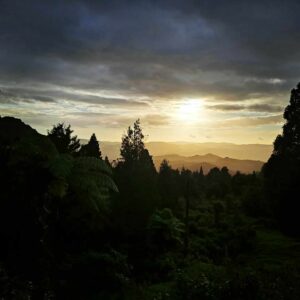
The weather, as always when traversing alpine environments threw me every season along the way. From a lovely warm hike along the Pelorus River to an entire day holed up in a hut with the fire on waiting out torrential rain 🌧🌧🌧 and clouds!!! I still haven’t seen more of Mt Rintoul than snow poles despite summiting its peak 🤦♀️⛰
The terrain along the way changed dramatically from river valleys and beech forest, to the open treeless rock of the mineral belts and red hills!!!
Despite these challenges this section was also full of more stunning forest, mist shrouded ridgelines, the satisfaction of reaching the top of another peak, cozy hut evenings eating dinner by the fire after an exhausting day and the comradery of teaming up with other hikers for the more challenging river crossings (I would have had to turn back many times without their help due to the deeper, swift flowing sections being unsafe for me to cross alone!!!)
A day holed up in a hut waiting out bad weather and a several shorter days to avoid bad weather means it took me 11 days to complete this section. Another tip for thru-hikes is to always carry at least 1 full days extra food, just in case you get delayed!

This was an unforgettable section for both its challenging nature and beautifully varied environments (but I will be very glad to see a section of flat hiking for a change 😅) and I can’t wait to continue my journey south.
Have you taken on the Richmond Ranges??? I would love to hear about your own adventure…and see any photos 📷 of your views from the tops as I saw mostly cloud and snow poles 🤣
Did you enjoy the Richmond Ranges? See Te Araroa Part 9 as I continue south!
For more photos from this section jump onto my Instagram page @discover_with_danni
Well done Danny
Pingback: Te Araroa Trail – Part 7 – Discover with Danni