
QUEENSTOWN – BLUFF
Section Distance = 313 km
Total Distance = 1830 km
QUEENSTOWN – TAIPO HUT
The looong home stretch for the south island began at the Greenstone/Cables carpark on the opposite side of Lake Wakatipu.
The nice easy trail through beech forest developed into a boggy, tree root strewn track, through tussock taller than me (this led to several “where the heck is the marker” moments) and into Taipo Hut. Some emergency plumbing work involving a frypan, hikers wool and duct tape fixed the leaking pipe that was slowly flooding the hut floor…


TAIPO HUT – MAVORA LAKES CAMP
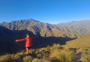
Taipo Hut to Mavora Lakes involved moody mountains and many km (it’s amazing how far I can walk without several mountains to summit along the way…)


MAVORA LAKES – TE ANAU
A long, hot day eating dust on a road walk from Mavora Lakes to Te Anau was brightened by my 80’s playlist and the thought of a cool shower at the end of it… I completed my highest number of km in a single day today, smashing out 36km before hitching into Te Anau for a re-supply. When you are only 5″2′ that’s a lot of steps!

TE ANAU – LOWER PRINCHESTER HUT
Te Anau to Lower Princhester Hut was only 6km (after hitching out of town and back to the trail) so I had a lovely afternoon to relax and read at the hut.
This was such a welcome chance to relax on trail and really savor the experience!

LOWER PRINCHESTER HUT – APARIMA HUT
The hike from Lower Princhester Hut to Aparima Hut involved a lot of effort for little gain…
Steep muddy forests, tree root covered track, tussock, alpine bog and mud… man was I glad to see that hut at the end of the day! There were some funny trail markers along this section, from an over-abundance of orange triangles to needing to use my phone like a periscope in the tussock that was taller than I was…

APARIMA HUT – TELFORD CAMP
Aparima Hut to Telford Campsite took me back into the Takitimu Forest before climbing up to Telford Tops and following the ridge all the way to the camp by the river.
I was super proud to not be overtaken by the taller hikers (which usually happens before lunch) only to find they had all taken a wrong turn and had to double back. Adding about 5km to their day…that explains it!


TELFORD CAMP – BIRCHOOD STATION
From Telford Camp we entered several sheep stations. Crossed through Linton Station into Birchwood Station and stayed in a lovely hut they had set up for TA hikers (showers, electricity AND the option to get the shuttle to the Takitimu Tavern for dinner 😲) talk about luxury!

BIRCHWOOD STATION – MERRIVIEW HUT
Leaving Birchwood Station behind for forestry roads and pine plantations the rain 🌧 rolled in after weeks of sunshine 🌞 which made everyone walk faster to get to Merriview Hut and curl up in our sleeping bags out of the weather.
After all the sunny weather our luck ran out just before a very muddy section 😬

MERRIVIEW HUT – MARTIN’S HUT
The Longwood Forest is notorious for 2 things; the last hut of the TA (Martin’s Hut – a very cute old hut) and MUD!!!
The rain thankfully cleared but the mud was definitely present. Knee deep, boot sucking, bog kind of mud! Full mud protection layers were in order and between my rain pants and gaitors I was at least clean underneath at the end of the day 🙃
With 5km to go for the day I was more than ready for any kind of solid path to tread upon!


MATIN’S HUT – RIVERTON
The track from Martin’s Hut was stunning forest with trees draped in moss, morning light filtered through ferns and trickling creeks…
After the forest was a short road walk into Colac Bay for lunch at the tavern.
The final beach leg into Riverton provided soft sand to add to the mud leg work out of the morning 🥾🥾🥾 and a final ascent over the only hill in the area…of course!


RIVERTON – INVERCARGILL
An early start from Riverton gave me another pretty sunrise to add to the memory banks and a long uneventful Beach walk (on solid sand this time) into Invercargill.

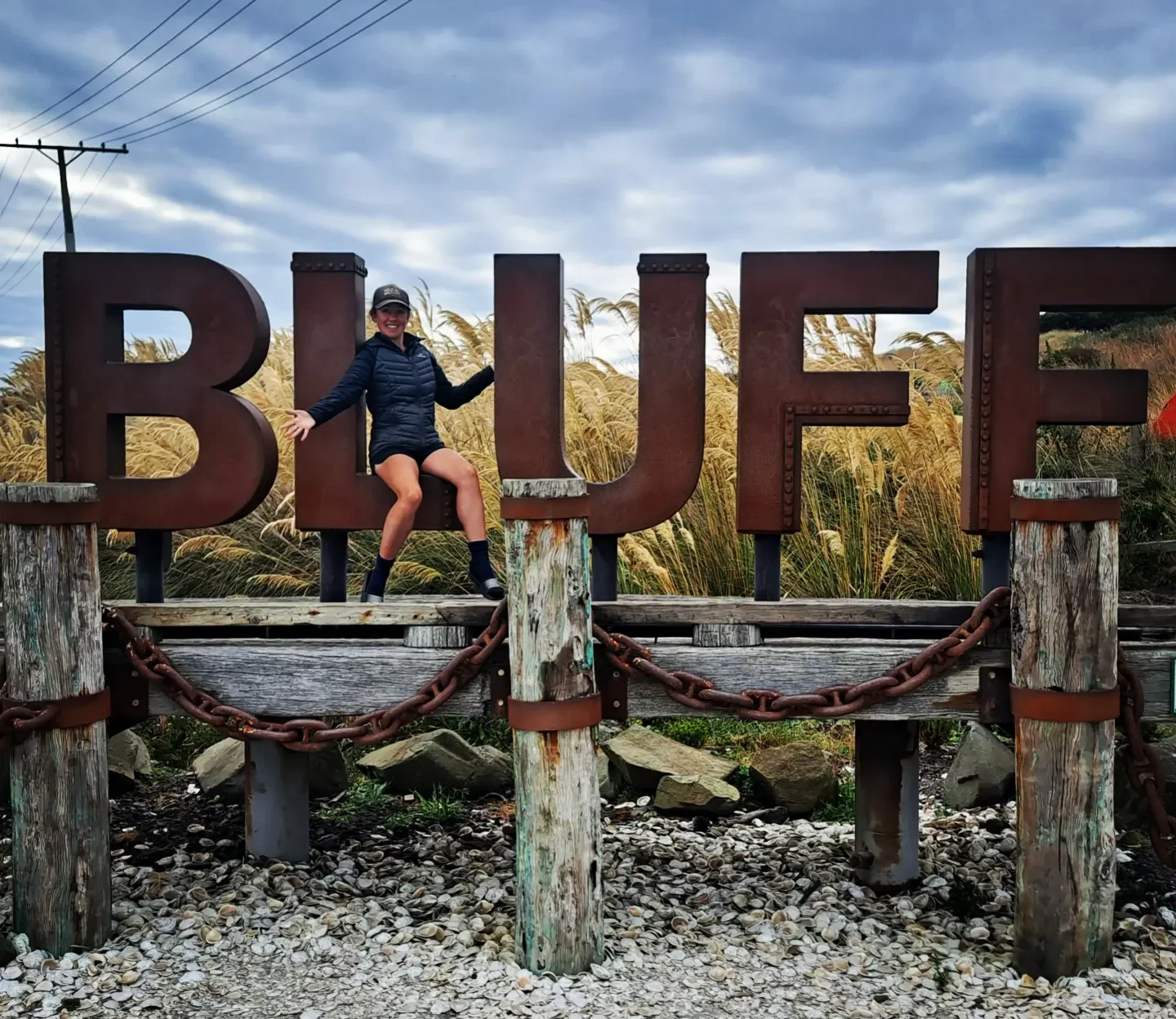
INVERCARGILL – BLUFF
The Invercargill to Bluff home stretch started in the dark and ended with me hugging the signpost!
The 35km followed a cycle track besides the road (thank goodness I didn’t have to walk all that way on the road!!!) which makes for boring but efficient walking.
The final 8km along the Foveaux Walkway showcased rugged coastline overlooking Stewart Island.
I had both my hiking family from the last few weeks and the lovely members of the Bluff Hill Motupohue Environment Trust (another of the community groups I am fundraising for) meet me at the signpost 🤗

As exciting as reaching Bluff was, I still have a long way to go and I’m looking forward to chasing summer north as I change direction and head for another signpost, this time at Cape Reinga…
But before I do, I’m taking a little side trip to hike the Rakiura Track on Stewart Island! Check out the details in Te Araroa Part 14.

Are you enjoying following my journey?
Pingback: Te Araroa Trail – Part 12 – Discover with Danni